Why should I use polarimetric data?
What exactly is the polarimetric radar mode?
The switch to polarimetry is like the arrival of color after black and white. The images are more beautiful…

More generally, what is radar polarimetry?
It’s making images by varying the polarization — in a way, the vibration orientation — of the emitted/and or received wave. Choosing different polarizations will modify the recorded signal, as long as the imaged object is anisotropic…which is the case for most objects on our planet!
When we acquire an image for all the polarizations that form a base in transmission and reception, then we say that we have a totally polarimetric image. The best known base of acquisition is the (H,V) base. H stands for horizontal, and V for vertical.
In this case a complete polarimetric image will include images in HH, HV, VH and VV. With a fully polarimetric acquisition, it becomes possible to synthesize an image for any transmit or receive polarization. In a monostatic configuration, i.e. with transmitter and receiver collocated, then symmetry properties mean that 3 polarimetric channels are sufficient to describe all that can be measured, because statistically, HV=VH.
3 channels is very practical: it is like 3 RGB channels, and we can then make a false color image. And since we have more information, we hope very much that it will help to make better classification maps.
Most people stop there.
In reality, you have to understand that polarimetric channel analysis can go much further: not only are the potential applications broader (detection, 3D, contrast optimization), but polarimetry contains much more than the three HH, HV and VV amplitude channels:
- The relative phases between polarimetric channels contain useful information.
- The theory of radar polarimetry includes the statistical analysis of second order statistical moments…the notions of variance which enriches the nature of the information. It is with these parameters that we study the notion of polarimetric entropy, or more generally the notion of depolarization.
In total, with totally monostatic polarimetric acquisition conditions, we obtain polarimetric information with 9 degrees of freedom.
But then, why so few polarimetric images?
These images are rare, at the satellite level. Sentinel-1 satellite images are only partially polarimetric: stripmap images acquired over continental surfaces are acquired in VV and VH polarizations.
Why is this? Because the more polarimetric channels are used, the higher the technological cost! So the gain in performance must be there to justify the investment. This is complex to do: before being able to find out what the gains are, you have to test. Polarimetric processing is often first evaluated on airborne images, because they are less expensive.
The problem is that when we move to the satellite level, we are rarely in the same acquisition conditions: the resolutions and geometries used are not exactly the same. And if a configuration is new, most of the time, we have big surprises when we analyze the first images!
Moreover, airborne images are less often shared. But I have good news: if you want to get familiar with polarimetric images, the UAVSAR site distributes its data for free: https://uavsar.jpl.nasa.gov/cgi-bin/data.pl

Finally, in my opinion, polarimetry has often had a bad reputation because polarimetric images often have coarser resolutions than those acquired by the same sensor in a single polarization. This is because azimuthal resolution is related to the pulse repetition rate, and increasing the pulse repetition rate to alternate polarizations has a significant cost.
This loss of resolution is always a problem for data processors, especially in urban areas. So let’s compare what is comparable! If we really want to know what polarimetry can do for us, we need to make a comparison between “with polarimetry” and “without polarimetry” images of the same resolution!
So when to use and why use polarimetric images?
Why are polarimetric images useful? When do we really need all the polarizations? This is the subject of this book, published by Springer thanks to ESA, following a collaborative work with researchers around the world, for each of the major issues of Earth observation: forests, agriculture, oceans, cities, ice. For each of these application areas, you will find a summary of the contributions of polarimetry.
For the forest, the polarimetric richness brings a substantial gain for model inversions and biomass estimation. This is why the future BIOMASS mission is highly anticipated!
As far as I am concerned, I would like to add an essential element, which I am convinced will give new interest to radar polarimetry: time series, especially in an urban environment:
- deformation measurements
- change detection
Indeed, the major application in urban environments for which polarimetry has shown its interest is the selection of so-called “permanent scatterers”, i.e. those scatterers on which it is possible to estimate ground deformations with a very high accuracy. To select as many permanent scatterers as possible, it is important to have as many polarizations as possible
In parallel, my most recent studies show that, for the detection of an “anomaly” within a time series, i.e. an object that occurs during a single acquisition in a time series, in urban environments, this anomaly is only detected in one of the polarimetric channels. This means that, in the best case of a single polarimetric acquisition, at best 40% of such events will be detected.
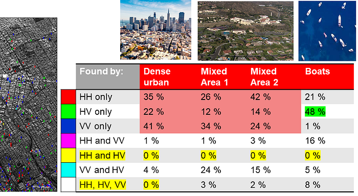
This conclusion will be very different over the sea, for which the HV channel continues to offer the best contrast.
So I feel like saying, in memory of the great Professor Wolgang Boerner: “do polarimetry!”
Bottom Line
● Polarimetry offers a greater wealth of information.
● The fully polarimetric mode allows us to obtain polarimetric information in a 9-dimensional space. In addition to the 3 original amplitudes, we must add the relative phases and the notions of covariance between channels.
● Polarimetry improves the performance of classification, detection, inversion and reconstruction of 3D information because it exploits the anisotropic behavior of objects
● Polarimetry plays a very important role in time series!
Polarimetric radar images: from acquisition to inversion.
UNIVERSITE PARIS SUD, FACULTE DES SCIENCES D’ORSAY, 2014
